|
| » Участники » Zander » Панорамы » Собор Св.Вита, Прага, Чехия |
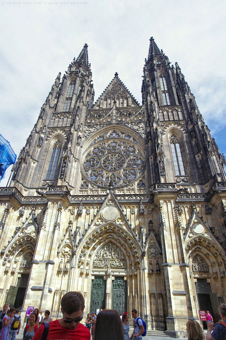
| Собор Св.Вита, Прага, Чехия |
 |
 | |
|

Собор Св.Вита, Прага, Чехия
- Раздел: Путешествия
- Дата съёмки: 27.08.2015 15:29
- Дата загрузки фото: 01.09.2015 22:31
- Оригинальная фотография: 1200 x 1800 (680 Кб)
- Технические характеристики:
- Фотоаппарат: Pentax K-r
- Выдержка: 1/350
- Гиперфокальное расстояние: inf m
- Диафрагма: 8,0
- Светочувствительность: 200
- Фокусное расстояние: 18,0 mm (35 mm equivalent: 18,0 mm)
- Полный EXIF
- Composite
- Aperture: 8,0
- CircleOfConfusion: 0,027 mm
- FOV: 90,0 deg
- FocalLength35efl: 18,0 mm (35 mm equivalent: 18,0 mm)
- GPSAltitude: 270,3 m Above Sea Level
- GPSDateTime: 2015:08:27 12:29:18Z
- GPSLatitude: 50 deg 12' 21,00" N
- GPSLongitude: 17 deg 9' 37,00" E
- GPSPosition: 50 deg 12' 21,00" N, 17 deg 9' 37,00" E
- HyperfocalDistance: inf m
- ScaleFactor35efl: 1,1
- ShutterSpeed: 1/350
- ExifIFD
- ColorSpace: sRGB
- ComponentsConfiguration: Y, Cb, Cr, -
- Contrast: High
- CreateDate: 2015:08:27 15:29:18
- CustomRendered: Normal
- DateTimeOriginal: 2015:08:27 15:29:18
- ExifImageHeight: 6339
- ExifImageWidth: 4226
- ExifVersion: 0221
- ExposureCompensation: 0
- ExposureMode: Auto
- ExposureProgram: Aperture-priority AE
- ExposureTime: 1/350
- FNumber: 8,0
- Flash: Off, Did not fire
- FlashpixVersion: 0100
- FocalLength: 18,0 mm
- FocalLengthIn35mmFormat: 20 mm
- ISO: 200
- MeteringMode: Spot
- Saturation: Normal
- SceneCaptureType: Standard
- SensingMethod: One-chip color area
- Sharpness: Hard
- SubjectDistanceRange: Distant
- WhiteBalance: Auto
- GPS
- GPSAltitude: 270,3 m
- GPSAltitudeRef: Above Sea Level
- GPSDateStamp: 2015:08:27
- GPSImgDirection: 3.43036
- GPSImgDirectionRef: True North
- GPSLatitude: 50 deg 12' 21,00"
- GPSLatitudeRef: North
- GPSLongitude: 17 deg 9' 37,00"
- GPSLongitudeRef: East
- GPSMapDatum: WGS-84
- GPSMeasureMode: 3-Dimensional Measurement
- GPSProcessingMethod: GPS
- GPSSatellites: 07
- GPSSpeed: 3,78
- GPSSpeedRef: km/h
- GPSStatus: Measurement Active
- GPSTimeStamp: 12:29:18
- GPSTrack: 49,96
- GPSTrackRef: True North
- GPSVersionID: 2.3.0.0
- IFD0
- Artist:
- Copyright: Zander
- Make: PENTAX
- Model: PENTAX K-r
- ModifyDate: 2015:09:01 22:20:17
- Orientation: Horizontal (normal)
- ResolutionUnit: inches
- SubfileType: Reduced-resolution image
- XResolution: 72
- YCbCrPositioning: Co-sited
- YResolution: 72
- System
|
- Просмотров: 268
- Рейтинг: голосов еще нет
- Отзывов: 0
|
-
Получить код для блога
| Вставка фотографии в текущем разрешении |
Вставка миниатюры |
HTML (для вставки в блог):
BBCode (для вставки в форум):
Ссылка на фото:
|
HTML (для вставки в блог):
BBCode (для вставки в форум):
Ссылка на миниатюру:
|
- Послать ссылку другу
|
| Комментарии к фотографии |
 |
 | |
|
|
|
|
|
